Thursday 12 September 2013


Progress in week 3 and another chance to visit us!


Throughout this week our team of volunteers have been working hard to uncover more of the #DigMinster site, as well as documenting the archaeology that we have observed so far, despite some wet weather restricting our work and delaying us at times. This has involved the professional archaeologists training small groups of volunteers in the methods and techniques of archaeological recording. To the newcomer, these concepts may seem fairly weird (and they often still remain so for many archaeologists as well!), but all the volunteers have accepted and risen to the challenge. We make sure all of the archaeological features we find are recorded properly and thoroughly as an excavation of a site, by its very nature, is a destructive exercise. As a result, making sure we have an accurate record of what we have found is always an essential part of the archaeological process, though this is especially pronounced when working in the sensitive conditions of a known graveyard.


Embedded image permalink
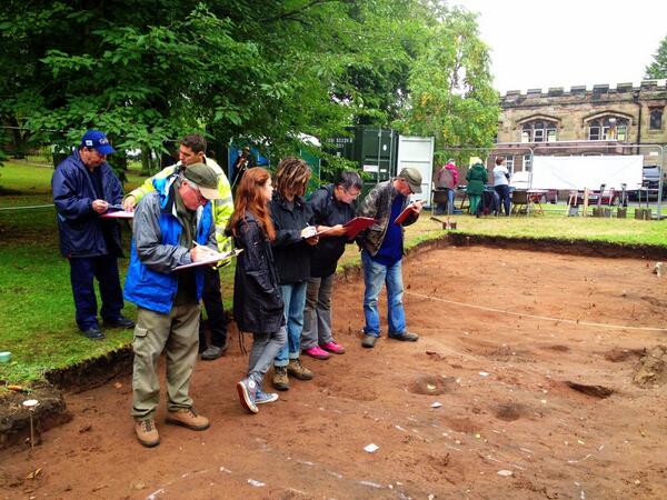
Explaining the art of 'context' recording to a group of volunteers; each archaeological feature is given a 'context number' and described in detail on individual 'context sheets'

Readers of this blog may remember us talking about our 'pre-excavation plan' in the previous post, a scale drawing of the site tied-in to a grid set out across the site area. This is now fully complete and all of the features seen in the trench have been marked onto it and the height at which they were observed has been worked out. This process of working out a height, called 'levelling', allows us to measure the position of our archaeology in relation to sea-level and thus it is recorded in the vertical as well as the horizontal position. With this, our site plans are transformed from a purely 2-D record into a 3-D one!

Embedded image permalink
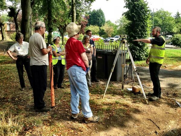
Archaeologist Mike Nicholson teaches our volunteers the principles of surveying using a dumpy level

With the completion of the plan and the ongoing recording taking place, we have been able to excavate deeper down in small areas of the site where graves are not going to be disturbed. These small test pits have been targeted onto some of the high response areas, or 'hotspots', seen on the geophysical survey and have been excavated for up to 1.5m below the ground surface. Unfortunately, as yet, all that has been encountered is natural sand and no structural remains or finds related to a possible early minster building have been found. This is disappointing, but not totally definitive in terms of ruling out the presence of a minster on this site. There is still plenty of work to be done before we get to that stage!         

Part of this further work has involved opening up our trench extension, which heads east from our main area into the centre of the area of potential building remains shown on the geophysical results. At the far end of the extended area we have encountered a brick structure, found just below the topsoil. This is certainly not a minster building, but it is interesting all the same; it is probably the brick platform for a 19th century box tomb and will be carefully planned, excavated and recorded over the coming days, just like the rest of the archaeology on the site. 

Embedded image permalink
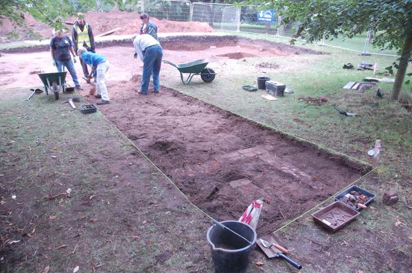
The trench extension during initial excavation. The remains of a brick structure are just being revealed at the end closest to the camera


Last Saturday we had a successful open day where visitors were welcomed onto the site. Hundreds of people came to see the work we are doing and were given site tours at regular intervals, with a report appearing in the Kidderminster Shuttle newspaper this week

This kept our boss Victoria very busy all day and the same thing will be happening this Saturday, except with a break for lunch this time! Also visiting us and setting up craft skills and combat areas just outside the dig area will be the Svartland Living History Society, a family-friendly re-enactment group who specialise in Viking and Anglo-Saxon demonstrations. 

Embedded image permalink
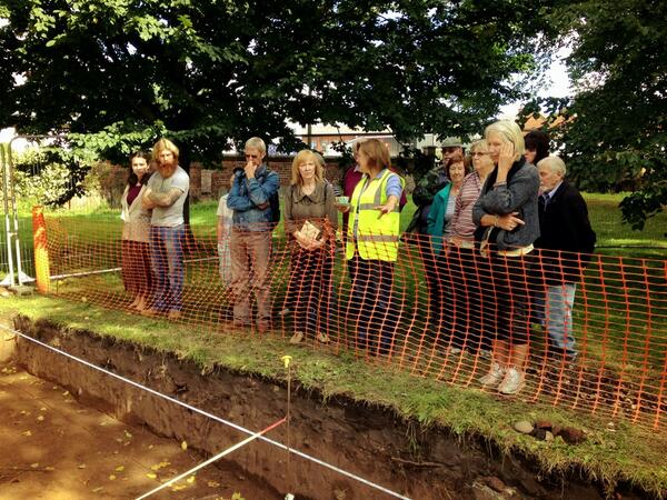
Victoria giving site tours to visitors at the Open Day last Saturday

So, once again, if you'd like to see the site, find out more about what we're up to and why we're doing it, see some of the finds and talk to the archaeologists and volunteers, come along to our Open Day this Saturday 14th September. We'll be there from 10:00 until 16:00. The postcode is DY10 2JN, and there is parking available in the public car park next to the Church.
If you can't make it, our DigMinster site Twitter account and Flickr page continue to be updated on a regular basis so you can follow what we are up to. Check them out!

Richard Bradley

Thursday 5 September 2013

Digging, trowelling, planning & a chance to visit us!

Over the past week, our volunteers have been working extremely hard. We've removed all of the topsoil from the area using mattocks and shovels. There's been a real mix of finds from the topsoil: we've found everything from this beautiful piece of prehistoric worked flint...

Prehistoric flint flake discovered within the topsoil
... to fragments of 20th century vinyl records. That's a date range of over 3000 years! To find such a variety of material within topsoil isn't unusual - topsoil is inevitably disturbed by roots, burrowing, landscaping and dumping of material, hence why artefacts from earlier, deeper deposits sometimes end up in the upper layers. Another process which will have brought older material close to the surface is the digging of graves within the churchyard.


Another star find: lovely writing stylus, perhaps dropped by a careless schoolchild...
As we mentioned in the last post, we have a poignant reminder of the fact that this used to be a burial ground in the fragments of headstones discovered lying loose and broken within the topsoil. On many, the writing is still legible, and after cleaning we've even been able to make out a few names.

Volunteer Beckie excavating a cluster of headstone fragments

Fragment of a very fine memorial stone
Once we'd finished removing the topsoil, we set about giving the area a thorough 'trowel clean'. If you followed the progress of our DigBromsgrove project, you'll have heard us wax lyrical about 'cleaning'. If not, and if you've been puzzled by the sight of lines of our volunteers on their knees dutifully scraping away at the soil with tiny trowels, we'd like to reassure you that it's not a sadistic punishment! In fact, it's crucial to identifying any archaeological features that might exist within, or 'cutting' into, a layer. We like to compare it to sanding a block of old wood - by carefully removing a thin slice, you expose the grain underneath. Likewise, a good trowel clean 'brings out' any changes in soil colour or texture that betray the presence of archaeological features.
 
Trowel-cleaning
In this case, the 'features' we're expecting to find at this level are graves - there's still a bit of soil to shift before we see any trace of the possible minster! We're trying to identify how many graves are within our area, whereabouts they are in relation to the possible building shown on the geophysics plot, and whether there's anything left of the occupants of the graves. Although the last burial in the churchyard was only around 150 years ago, bone degrades very quickly in sandy, acid soils, and many of the loose bone fragments we're coming across are little more than stains in the sand, crumbling to dust as we carefully extract them.

We want to locate any graves as accurately as possible because, if there's anything left of the remains interred within, we'll try to avoid disturbing them by going around them as we dig deeper. However, the graves have been tricky to locate. This is not uncommon, as graves don't tend to be left open for long, and the soil that comes out goes back in very quickly, so they can leave very little trace. The sunny weather and quickly drying soil doesn't help visibility, so we've been spraying the trowel-cleaned areas with water to make the subtle outlines of the features more visible.


Project Officer Andy Walsh sprays the cleaned areas with water. The white lines mark features, identified through changes in soil colour and texture. Archaeologist Ruth Humphreys is excavating a small trial hole to check the profile of the feature. It's rectangular in shape, with vertical sides - the typical profile of a grave.
Once we've identified all of the features within an area, the volunteers got to work producing the 'pre-excavation plan', a carefully measured scale drawing of the area tied-in to a grid set out across the site. This will help us to determine which areas we can target to excavate deeper, and hopefully locate the source of the tantalising geophysics!


Producing the scale 'plan'
If you'd like to see the site, find out more about what we're up to and why we're doing it, see some of the finds and talk to the archaeologists and volunteers, come along to our Open Day this Saturday 7th September. We'll be there from 10:00 until 16:00. The postcode is DY10 2JN, and there is parking available in the public car park next to the Church. All ages are welcome. We look forward to seeing you then!

Rob Hedge

Thursday 29 August 2013

And we're off...

Today is our third day on site, and we're into the swing of the dig. On the first day, we removed the turf from the excavation area. On many archaeological excavations, this stage is carried out using a mechanical excavator, but due to the sensitive nature of the site and the potential for the presence of human remains, we're doing it all by hand.

Our volunteers begin the de-turfing under the supervision of Archaeologist Ruth Humphreys

On Day 2, we began to dig down through the topsoil to expose the sandy orange subsoil beneath.
 
Removing the topsoil

There's a wide variety of finds coming out of the topsoil, from fragments of decorative iron railing that once would have circled tombs and pieces of broken headstones, to Victorian pottery and a 17th century coin. Inevitably, given that the site is a former graveyard, we're finding fragments of 'disarticulated' (loose) human bone, which have been moved around in the soil by burrowing animals and landscaping. The human remains are kept aside from the rest of the finds, and will be re-buried on the site once the excavation is finished.

Headstone fragment discovered within the area of the rockery

Many people have asked us about GSB Prospection's geophysical survey, which provided the target for this dig. Below is a plan showing the Ground Penetrating Radar (GPR) response in relation to the church, with our excavation area marked. The red splodges indicate solid materials, which we hope may correspond to the locations of buried remains of walls belonging to an early building on the site. Is it the Saxon Minster? Watch this space!

The geophysical survey by GSB Prospection: this plan shows GPR response at a depth of 1.3m below ground level

Rob Hedge


Monday 19 August 2013

Welcome to the #DigMinster Blog

Between 27th August and 21st September, an intrepid band of volunteers will be getting their hands dirty in the latest phase of the Kidderminster Civic Society's 'Historic Kidderminster Project'. They'll be carrying out an archaeological excavation within St Mary's Churchyard, in an attempt to shed new light on Kidderminster's history.

The volunteers will be led by professional archaeologists from Worcestershire Archive & Archaeology Service. Those of you who followed the progress of our #DigBromsgrove excavation will be pleased/dismayed to learn that once again, the team will comprise site chief Richard Bradley, alongside glamorous assistants/minions Ruth Humphreys and Rob Hedge. Tom Vaughan is pulling the strings and masterminding the whole operation, and Justin Hughes will be leading school visits and open days.

Background to the project
As part of the Historic Kidderminster Project, funded between 2006-8 by the Local Heritage Initiative, a geophysical survey of St Mary's churchyard was carried out by GSB Prospection. A copy of the report is available here: (PDF 10mb). The survey was intended to determine whether any evidence could be found of the remains of the Saxon 'minster' that gave the town its name. The minster is thought to have been located in the area around the existing church: for an excellent summary of the evidence for its location, see this piece by Nigel Gilbert (PDF 22kb), the Historic Kidderminster Project Leader.

The geophysical survey detected a large anomaly to the north of the present church, which appears to be the remains of a building. A desk-based assessment (available here: PDF 600kb) subsequently carried out by Emma Hancox concluded that any such remains are highly likely to be medieval or earlier.

The excavation is taking place thanks to a further grant from the Heritage Lottery Fund of almost £50,000.

Archive & Archaeology Service Manager Victoria Bryant and Project Managers Tom Vaughan and Derek Hurst, planning the excavation


Find out more
Open days will be held on the 7th and 14th September. Visitors will get the chance to see the excavation in progress, find out more about the project and view some of the artefacts recovered. We'll be updating this blog regularly with our progress. Photos from the site will be posted on our Flickr page, and you can keep track of our live news and updates via our Twitter account. Search for the hashtag #DigMinster to keep up-to-date with the news across all our platforms.

Rob Hedge